Tag Archives: Maps

New Battles on Old Battlefields

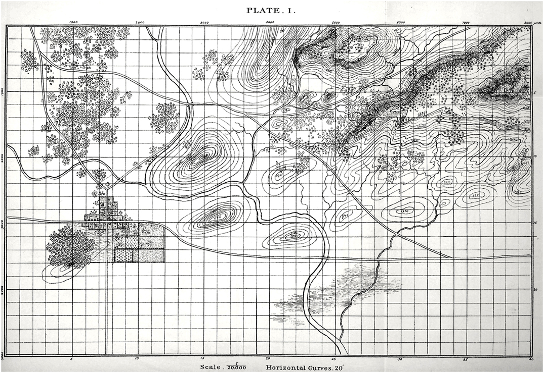
Plate 1 from, “The American Kriegsspiel. a Game for Practicing the Art of War upon a Topographical Map,” by W. R. Livermore, Captain, Corps of Engineers, U S Army published in 1882. Click to enlarge.

When I was about ten years old my father brought home an original copy of Esposito’s The West Point Atlas of American Wars. My life was forever changed. I had always been interested in military history and maps but now I could clearly see the complexity of tactical maneuvers and how these battles unfolded.

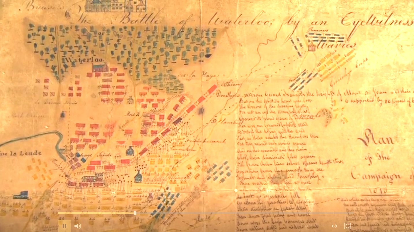
In previous blogs, I have written about my introduction to wargaming through Avalon Hill’s superb games. While diving deeper into the history of American wargaming I discovered Livermore’s American Kriegsspiel (by the way, it is available online from the Library of Congress here). When I first saw Plate 1, above, I couldn’t help but think of the officers at West Point, ‘practicing the Art of War’ on that black and white map.

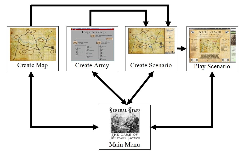
Consequently, one of the first things that I wanted to do with the General Staff Map Editor was bring Plate 1 back to life so new battles could be fought on it:

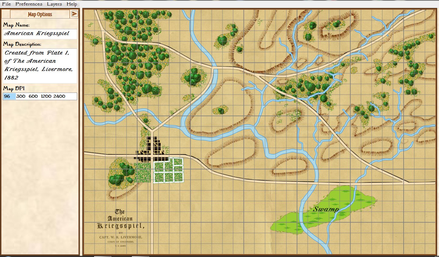
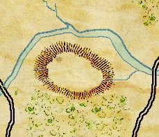
The American Kriegsspiel map imported into the General Staff Map Editor and converted for use with the General Staff Wargaming System. Grid lines are optional. Click to enlarge.

My good friend, Ed Isenberg, did the colorization and we added some new features in the Map Editor to support importing rivers, roads and other terrain features, from a PhotoShop image (for more information see the online documentation for the Map Editor here).

Importing the American Kriegsspiel map into the General Staff Wargaming System was a good beta test of the Map Editor. If you are an early backer you should have the location and password to download it. If, for some reason, you don’t have these, please contact me directly.

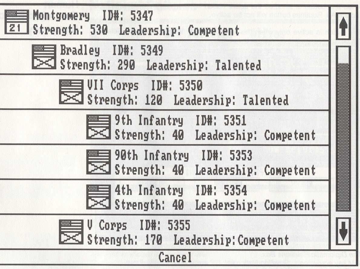
One of the interesting features of the General Staff Wargaming System is that any two armies created in the Army Editor can be combined to create a battle scenario on any map created in the Map Editor. Thinking about all the ‘mix and match’ combinations I decided to create an army, in the Army Editor, from the Order of Battle Table (OOB) for the French Imperial Guard, August 1, 1813 from George Nafziger’s, superb “Napoleon at Dresden,” book:

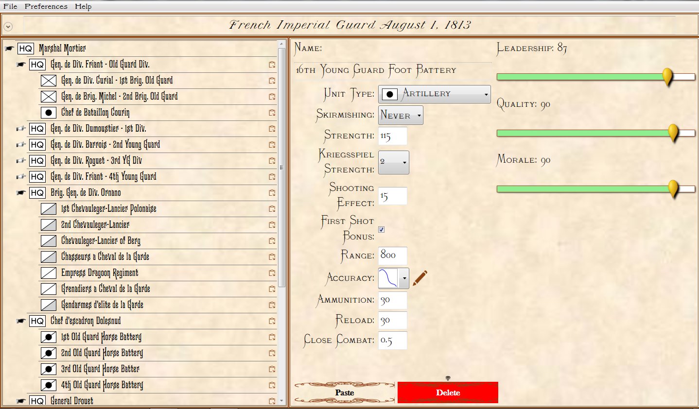
The French Imperial Guard Order of Battle in the General Staff Army Editor. Click to enlarge.

We are currently beta testing the General Staff Scenario Editor. Here I’ve imported the American Kriegsspiel map (from above) and the French Imperial Guard (from above). To position units, just click and drag from the OOB on the left:

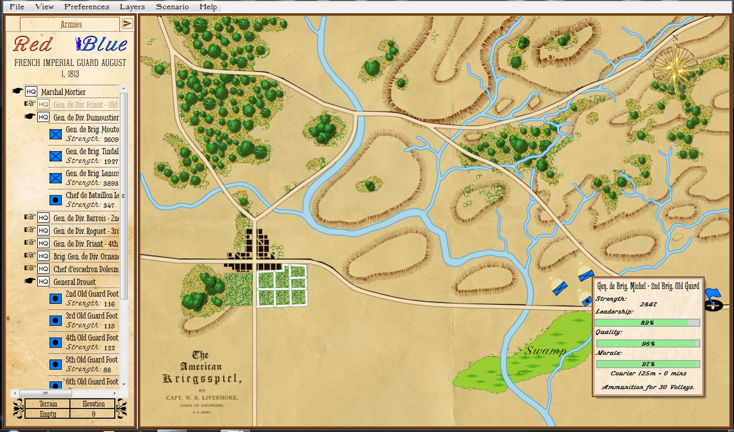
Screen shot of the General Staff Scenario Editor where the French Imperial Guard is being positioned on the original American Kriegsspiel map. Click to enlarge.

Hopefully, this will get your imagination going and thinking about what maps, armies and scenarios you would like to see. In addition to the ability to create your own new scenarios on old battlefields, General Staff will ship with 30 historical scenarios (the list is published in previous blogs).

Please feel free to contact me directly if you have any questions.

A Map of Waterloo Created by an Eyewitness

Screen shot of the Map of Waterloo painted by an Eyewitness from Antiques Roadshow. This image has been brightened and the contrast increased for legibility. Click to Enlarge.

I happened to be watching Antiques Roadshow from Exeter on BBC America last night when this extraordinary map of the battle of Waterloo was presented. Though it bears no date or signature, it clearly was painted, “by an Eyewitness” shortly after the battle itself. I was immediately struck by the lettering  and how similar it was to our efforts in General Staff to recreate the look and feel of 19th century maps for our wargames.

Below is the link to the entire segment hosted on the BBC web site:

Link to Antiques Roadshow BBC clip, “Map of Waterloo A beautifully detailed map of the 1815 Battle of Waterloo drawn by an unnamed eyewitness.”

How to Add Scale to Created Maps

One of the many interesting features in the General Staff Wargaming System is the ability to import maps from old atlases or from the internet. While we intend to film a complete instructional video (we’re thinking of including a set of instructional videos explaining how to use the Army Editor, Map Editor and Scenario Editor) we thought we would first share a sneak peek of how to import a map from an old atlas.

An integral part of my office library, a well-worn volume of “The Official Military Atlas of the Civil War”

The “The Official Military Atlas of the Civil War” is one of my favorite books and, like many Grognards, I have dreamed about maneuvering units across these famous maps. I recently realized that I now had all the tools to do exactly that with the General Staff Wargaming System.  First I scanned the map I wanted (the First Bull Run / Manassas battlefield) using an inexpensive flat-bed scanner attached to an ink-jet printer. Then I imported it into the General Staff Map Editor using the built-in feature.

Next, measure the distance between two key geographic points on the map using your trusty Rock Island Arsenal Museum & Gift Shop souvenir plastic ruler.

Measure the distance between key geographic features using a ruler.

Next look up the scale of the map at the bottom:

The scale of this map is 2,000 feet to the inch.

Use Google to do the math (yes, this is actually a programming assignment that is often assigned to first semester college students in CS1).

Three inches = 6,000 feet. Convert to meters.

Just learned that the reprint of the Official Atlas of the Civil War was printed 10% smaller than the original so 3 inches actually equal 5,400 feet!

Next, select the ‘Add Map Scale’ feature in the General Staff Map Editor.

Select the ‘Add Map Scale’ menu item.

Click and drag a line on the map between the same two key geographic features that you previously measured and enter the length in meters:

Enter the length of the line you just drew on the map in meters.

And – voila! – General Staff automatically calculates the map scale:

General Staff calculates and displays the scale of the map you just imported.

Help Us Decide: Splash Contours or Elevation Contours?

We need your input on how elevation (hills and ridges) will be displayed in General Staff. Originally we had planned on using ‘splash contours’. Splash contours were often used in quick sketch maps on the battlefield and they have an authentic look to them.

An example of a splash contour representing a hill (artwork by Ed Isenberg).

However, recently “Cry Havoc” – a Grognard on Facebook – asked if we were going to include the original Kriegsspiel Meckel map with General Staff. That got us thinking and taking another look at the original Kriegsspiel maps. Below is a map from the original American Kriegsspiel (circa 1892-8):

An original American Kriegsspiel map (circa 1892). Note the elevation contour lines. Click to enlarge.

Obviously, concentric elevation contours were in use in the 19th century so we could be authentic using either method of display.

This leads us to a very simple user survey:

[os-widget path=”/drezrasidran/splash-contours-or-concentric-elevation-contours” of=”drezrasidran” comments=”false”]

General Staff Features

General Staff is a direct descendant of the UMS seies which featured a suite of tools that allowed the user to create new maps, armies and scenarios. Our recent survey indicated that 73% of respondents felt that it was either ‘very important’ or ‘somewhat important’ for General Staff to have these abilities, too. Below is a flow chart of the five modules that make up General Staff:

Flow chart of General Staff. From the main screen the user can either create a new map, create a new army, combine a map and two armies into a new scenario or play a previously created scenario. Click to enlarge.

Flow chart of General Staff. From the main screen the user can either create a new map, create a new army, combine a map and two armies into a new scenario or play a previously created scenario. Click to enlarge.

From the Main Menu the user can select:

The Create Map Module

This module provides all the tools that a user needs to create detailed, authentic-looking maps. The are numerous tiles that represent the eight different terrains (field, water, swamp, city, woods, bridge, road, fort). Additionally, the user can sculpt hills and ridges with the AI automatically adding ‘splash contours’. Rivers and roads are added using a Bézier curve tool.

After the map is completed the user can select the amount of ‘dirtying’ (map folds, coffee stains, age stains, etc.) to be added to the map.

The Create Army Module

Armies can be in either an hierarchical format (see below) or a flat format. A flat format is a data structure without layers of commanders. Next week we will be running a user survey to find if you have a preference for hierarchical or flat army unit structures.

Screen shot from UMS II: Nations at War showing a hierarchical army structure. There are four levels of command in this army structure: Army Group, Army, Corps and Division. Click to enlarge.

The original UMS had a flat army structure while UMS II had a hierarchical unit structure.  For both systems an intuitive click and drag interface is provided for quickly creating, editing and saving armies.

Available unit types include: heavy and light infantry, heavy and light cavalry and heavy and light (horse) artillery. Headquarters and courier units are provided for hierarchical army structures.

Create Scenario Module

In the Create Scenario Module a user can combine any two previously created armies with a previously created map to create a new scenario. Mix and match to your heart’s content! The Napoleonic Imperial Guard against the Army of the Potomac’s First Army Corps on the Gettysburg battlefield! The battle of Marengo re-fought with Russian and Austrian troops! Obviously, you can also create historically accurate scenarios, too.